EDNY - Friedrichshafen
General
Description
Friedrichshafen Airport (EDNY/FDH) is located in the southern part of Germany, directly on the shores of Lake Constance (Bodensee), near the borders of Switzerland and Austria. Despite its relatively compact size, the airport serves as an important regional gateway for both business and leisure travel within the Lake Constance region.
The airport is known for its scenic surroundings and visually distinctive approaches, particularly during operations along the shoreline of Lake Constance. Due to its proximity to Lake Constance and the Alpine region further south, weather conditions around EDNY can change rapidly, particularly during low visibility situations, fog formation and winter operations.
Friedrichshafen itself is widely recognized as the historical home of German aviation and aerospace development. The city became internationally known through Count Ferdinand von Zeppelin, whose airship development originated in the region during the early 20th century. Even today, aviation and technology remain strongly connected to the local identity.
Beyond aviation, the Lake Constance region is one of the most popular leisure and tourism destinations in Central Europe. The area is characterized by:
- picturesque lakeside towns
- vineyards and rolling countryside
- Alpine scenery
- maritime culture around the lake
The region attracts visitors year-round for outdoor activities, tourism, trade fairs and cultural events. During summer months especially, the area experiences increased tourism traffic due to its favorable climate and proximity to the Alps.
Operationally, EDNY combines the atmosphere of a regional airport with the environmental and weather-related considerations typically associated with more terrain-sensitive destinations.
Surrounding Area
The area surrounding EDNY is characterized by relatively flat terrain north of the airport and progressively rising terrain towards the south and southeast in the direction of the Alpine region. While the airport itself is not considered terrain-critical, terrain awareness becomes increasingly important during southbound departures and operations in reduced visibility conditions.
Lake Constance (Bodensee), located directly south of the airport, serves as one of the most prominent geographical and visual references in the region. The shoreline is frequently used for visual orientation during arrivals and departures, particularly during RWY 06 operations where aircraft are commonly vectored along the lakeside instead of flying extended straight-in approaches. Due to the popularity of the lake region for general aviation and sightseeing flights, increased crossing VFR traffic can frequently be expected along the shoreline area.
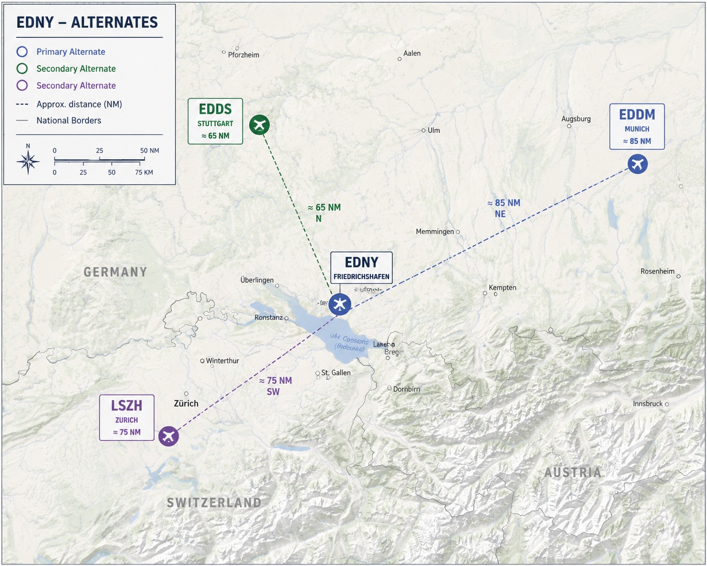
Several notable airports are located within short distance of EDNY. Zurich Airport (LSZH) is located approximately 75 NM southwest of EDNY and acts as the primary international hub in the region. St. Gallen–Altenrhein (LSZR) lies around 12 NM southeast of EDNY directly across Lake Constance in Switzerland. Memmingen Airport (EDJA) is located approximately 35 NM northeast of EDNY, while Munich Airport (EDDM), the primary BlueLake Airways alternate airport for EDNY operations, is situated roughly 85 NM northeast of Friedrichshafen.
The surrounding airspace is influenced by the close proximity of German, Swiss and Austrian FIR boundaries, resulting in frequent cross-border traffic throughout the region. Traffic density is generally moderate but can increase significantly during regional events and online network operations.
Important visual landmarks in the area include the Lake Constance shoreline, the Friedrichshafen waterfront, the Zeppelin Hangar and museum complex, local ferry terminals and the Alpine mountain range visible south of the lake. Fog and reduced visibility conditions are common near the lake area, especially during colder seasons and early morning operations.
Alternates
Primary Alternate – Munich (EDDM)
Munich Airport (EDDM) serves as the primary BlueLake Airways alternate airport for EDNY operations. Located approximately 85 NM northeast of Friedrichshafen, EDDM provides extensive operational capabilities including multiple precision approaches, parallel runway operations and highly reliable all-weather infrastructure. Due to its size and traffic density, crews should expect significantly higher ATC workload, longer taxi times and possible sequencing delays compared to EDNY. During low visibility conditions at Friedrichshafen, Munich frequently remains operational due to its advanced CAT II/III capabilities and overall airport infrastructure.
Secondary Alternate – Stuttgart (EDDS)
Stuttgart Airport (EDDS), located approximately 65 NM north of EDNY, serves as an additional alternate option for operations within southern Germany. The airport offers reliable IFR infrastructure and generally lower traffic density compared to Munich, while still providing sufficient operational flexibility for diversion scenarios. Due to its elevated terrain environment and surrounding hills, crews should remain aware of terrain-related considerations during arrivals and departures, particularly during adverse weather conditions.
Secondary Alternate – Zurich (LSZH)
Zurich Airport (LSZH), located approximately 75 NM southwest of EDNY, acts as another highly suitable alternate airport within the region. As one of Central Europe’s major international hubs, LSZH provides extensive operational redundancy and excellent approach infrastructure. However, crews should be aware of the airport’s complex airspace structure, frequent traffic congestion and noise-sensitive operational procedures. During peak traffic periods or event operations, arrival sequencing and holding delays can be expected.
Airport
Layout
EDNY features a compact and straightforward airport layout with a single runway and a relatively small apron environment. The airport infrastructure is optimized for regional and short-haul operations, resulting in short taxi distances and simple ground routing procedures.
The passenger terminal and main commercial apron are located south of the runway. Commercial airliner operations are primarily conducted from stands 201 to 203, which are the only dedicated airliner parking positions at the airport. All stands are configured for taxi-in and taxi-out operations, meaning no pushback procedures are required.
General aviation facilities and smaller parking areas are located southwest of the main commercial apron. Helicopter and business aviation traffic can frequently be observed in these areas, especially during seasonal traffic peaks and regional events.
Taxiway infrastructure at EDNY is limited but efficient, with direct apron access to the runway and minimal routing complexity. Due to the compact airport design, taxi times are usually very short and rarely exceed a few minutes under normal traffic conditions.
The runway is oriented roughly perpendicular to the Lake Constance shoreline, creating visually distinctive arrival and departure environments. During RWY 06 operations, aircraft are frequently vectored along the lakeside shoreline before turning northbound onto final approach. The open lake area south of the airport provides excellent visual references during both arrivals and departures, while rising terrain becomes increasingly visible further towards Austria and the Alpine region.
Due to the limited apron space and compact maneuvering areas, situational awareness during ground operations remains important, particularly during online network events or periods of increased general aviation activity.
Gates
BlueLake Airways operations at EDNY are limited to parking positions 201 through 203, which are the only stands suitable for regular A319 operations. All positions are located on the main commercial apron south of the runway and provide direct access to the terminal building.
The stands are configured for taxi-in and taxi-out operations only. Pushback procedures are not used at EDNY due to the apron layout and limited maneuvering area. Crews should therefore carefully consider departure routing and nosewheel alignment during stand entry to ensure sufficient clearance for the subsequent taxi-out.
Taxi routing between the runway and the commercial apron is generally straightforward due to the compact airport layout. After landing, aircraft are usually instructed directly onto the apron area with minimal taxi distance. During RWY 24 operations, crews should remain aware of the relatively short taxi routing and prepare for early taxi speed reduction when entering the apron environment.
When departing from stands 201–203, taxi-out is performed under own power with a forward taxi maneuver onto the apron taxi lane before proceeding towards the active runway. Due to the limited apron space and potential presence of general aviation traffic nearby, precise taxi handling and continuous situational awareness are essential.
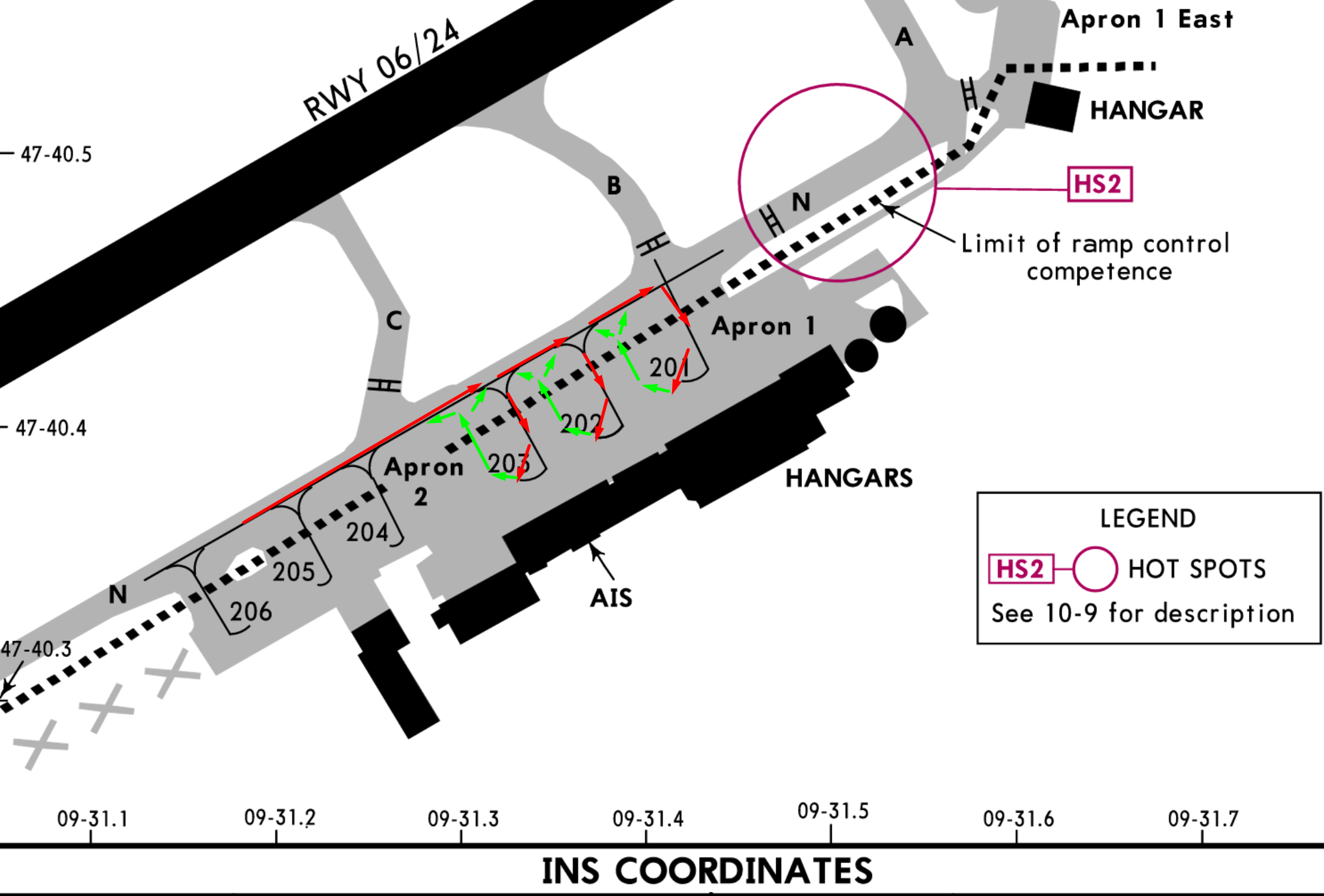
During turn-out from the parking positions, only the outer (left) engine should be used in order to minimize impact on the surrounding area. Additionally, taxi and turn-off lights should remain switched off while maneuvering out of the stand.
During online network events or increased traffic situations, temporary holding on the apron may be required before taxi clearance can be issued, as the maneuvering space for simultaneous ground movements at EDNY is limited.
Taxiways
EDNY features a simple and compact taxiway system with short taxi distances and minimal routing complexity. Due to the limited maneuvering area and tight apron environment, careful taxi handling and situational awareness remain important during both arrival and departure operations.
RWY 06 Operations
Arrivals
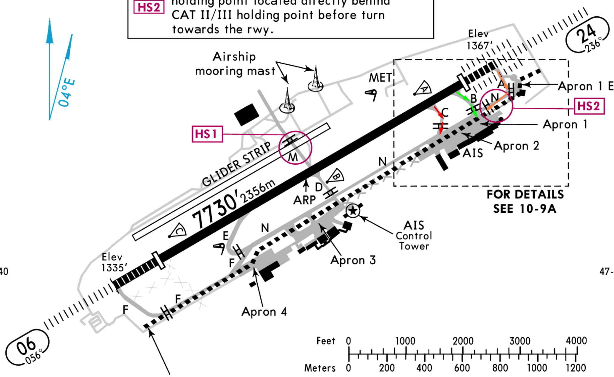
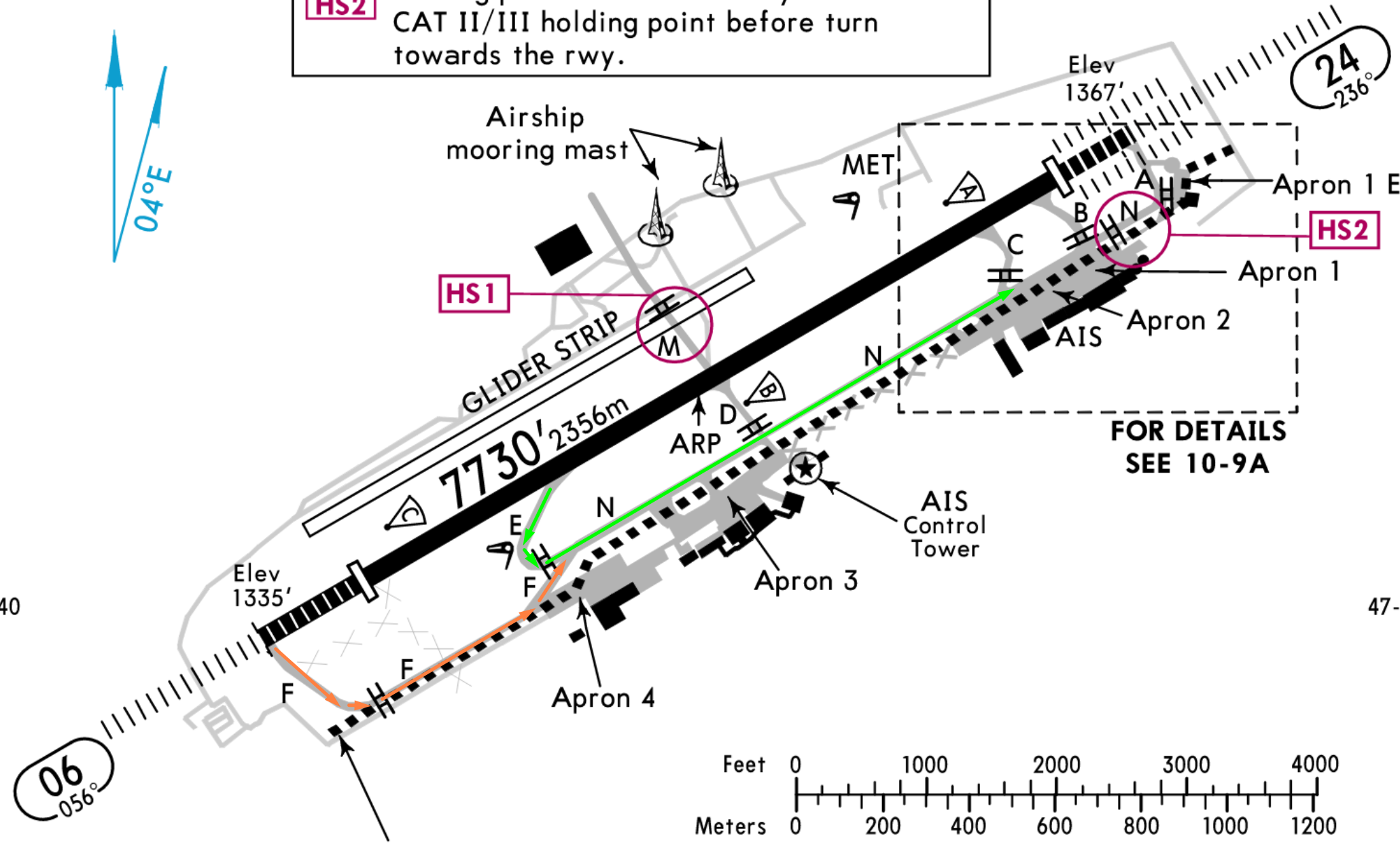
During RWY 06 operations, BlueLake Airways aircraft are expected to vacate the runway via taxiway B whenever operationally possible. After vacating via B, taxi routing towards the commercial apron is performed directly via taxiway N towards stands 201–203.
If taxiway B is missed, aircraft should continue to taxiway A and proceed back towards the apron via taxiway N.
Taxiway C is not used during RWY 06 operations. Due to the required left turn onto taxiway N and the limited maneuvering geometry in this area, taxiway C is considered unsuitable for routine A319 operations.
Departures
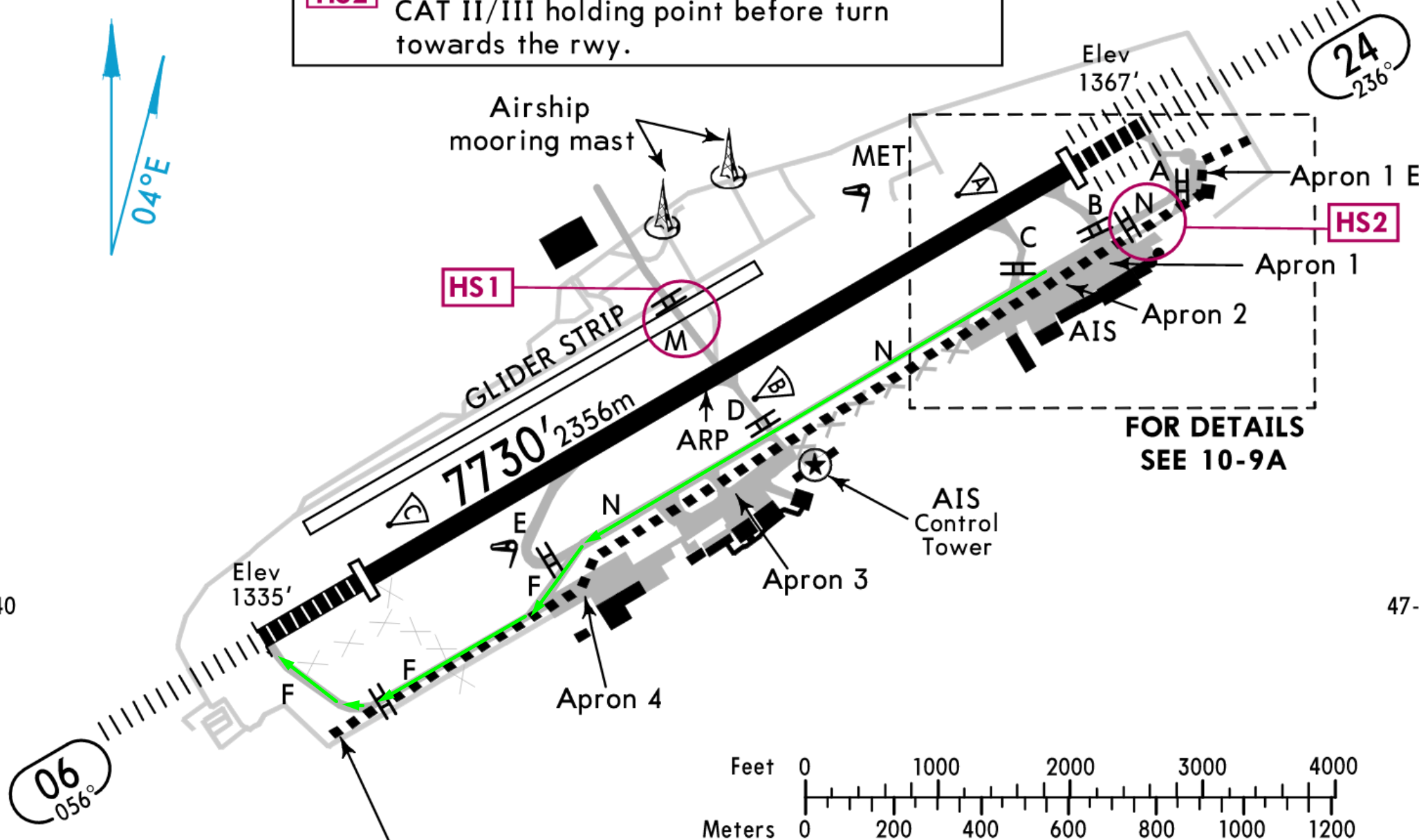
For RWY 06 departures, aircraft normally taxi from the commercial apron via taxiway N and continue towards the runway via taxiway F.
RWY 24 Operations
Arrivals
During RWY 24 operations, the preferred runway exit is taxiway E. After vacating the runway, aircraft should continue via taxiway N towards the commercial apron and stands 201–203.
If taxiway E is missed, aircraft should continue to taxiway F and taxi back towards the apron area via taxiway N.
Departures
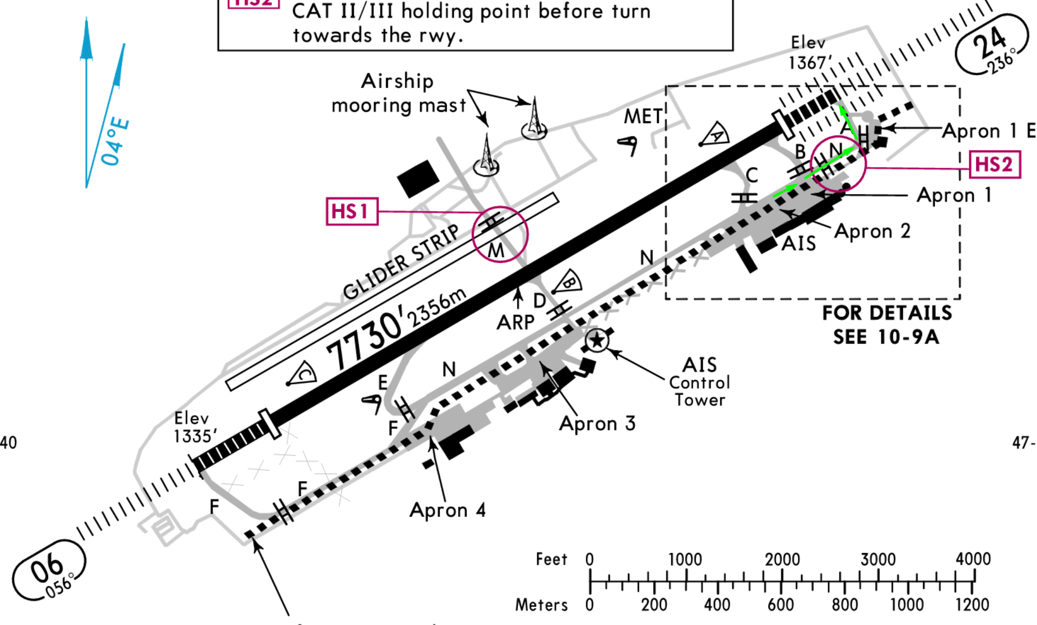
For RWY 24 departures, aircraft normally taxi from the commercial apron via taxiway N and continue towards the runway via taxiway A.
Continuous situational awareness is required during all ground operations due to the compact maneuvering area and possible general aviation traffic near the apron environment.
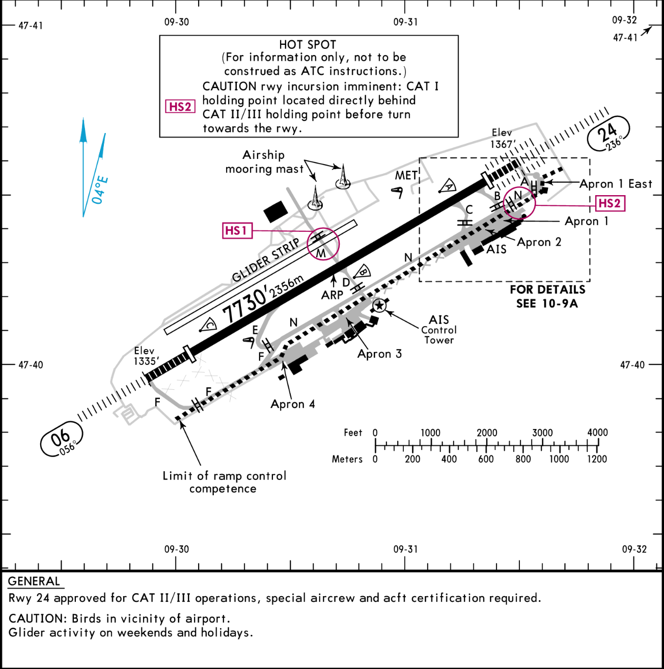
Runway
RWY 06
RWY 06 is one half of the single runway system at EDNY and has an approximate magnetic orientation of 058°. The runway surface is asphalt and forms part of the airport’s only operational runway, designated 06/24.
The runway measures approximately 2,356 meters in length and 45 meters in width, providing sufficient operational capability for regional and medium narrowbody aircraft operations, including regular Airbus A319 services. The runway is equipped with standard centerline and edge lighting systems as well as precision approach infrastructure supporting IFR operations.
RWY 06 features a displaced threshold configuration and includes standard runway markings for precision operations. Due to the relatively limited overall runway length compared to major international airports, accurate performance calculations remain important, particularly during adverse weather conditions, contaminated runway operations or high-weight departures.
For RWY 06 arrivals, the preferred runway exit is taxiway B. Aircraft can expect an approximate landing distance of around 1,500 meters before reaching the preferred exit point. If taxiway B is missed, taxiway A is available further down the runway.
RWY 24
RWY 24 represents the reciprocal direction of EDNY’s single runway system and has an approximate magnetic orientation of 238°. Like RWY 06, the runway surface consists of asphalt and supports all commercial airline operations at the airport.
The runway dimensions are approximately 2,356 meters in length and 45 meters in width. RWY 24 is equipped with the airport’s primary precision approach infrastructure and serves as the standard operational runway during most prevailing wind conditions. The runway provides full centerline and edge lighting as well as the required visual aids for low visibility and nighttime operations.
The available runway length allows unrestricted routine A319 operations under normal conditions, although performance considerations remain relevant during wet, contaminated or winter runway conditions due to the airport’s regional infrastructure and limited turnaround area.
For RWY 24 arrivals, the preferred runway exit is taxiway E. Aircraft can expect an approximate landing distance of around 950 meters before reaching the preferred exit point. If taxiway E is missed, taxiway F is available further down the runway.
To generate a bigger landing distance, the final approach can be flown visually, which increases the landing distance until taxiway E up to 1,150 meters.
Specials
Boarding Procedures
All commercial stands at EDNY are configured for walk boarding operations. Passenger boarding bridges and apron buses are not used. Boarding and deboarding are conducted directly on the apron via mobile stairs, requiring increased awareness for surrounding ground activity during turnaround operations.
Weather Conditions
Weather conditions around EDNY can change rapidly, particularly during morning operations and colder seasons. Reduced visibility, fog and changing cloud layers can develop quickly due to the airport’s proximity to Lake Constance.
General Aviation Activity
Increased general aviation and business jet traffic can frequently be expected around taxiway N and the general aviation apron areas, especially during summer operations and good weather conditions. Crews should maintain continuous situational awareness during taxi operations due to the close interaction between commercial and private aviation traffic.
Approach / Departure
STARs
Published STAR procedures into EDNY are operationally limited and are therefore not consistently used during BlueLake Airways operations. Due to the airport’s regional traffic environment, compact airspace structure and frequent vector-based sequencing, arrivals are commonly handled via direct routings and radar vectors rather than full STAR transitions.
Depending on traffic volume, runway configuration and ATC workload, crews should expect partial STAR usage, shortened transitions or completely vector-based arrivals. In many situations, only the initial portion of a published STAR is flown before radar vectors are issued towards the final approach phase.
The relatively short distances between nearby airspace sectors, combined with the compact operational environment around EDNY, often make full STAR procedures operationally unnecessary. This is particularly noticeable during low traffic periods, online network operations or regional ATC staffing situations where controllers may prioritize efficient sequencing over procedural arrivals.
Crews should therefore remain prepared for:
- frequent direct-to clearances
- abbreviated STAR transitions
- early descent instructions
- radar vectoring towards final approach
Full STAR compliance should nevertheless remain available whenever specifically instructed by ATC or required due to traffic sequencing and operational conditions.
RWY 06 – Arrivals via KPT
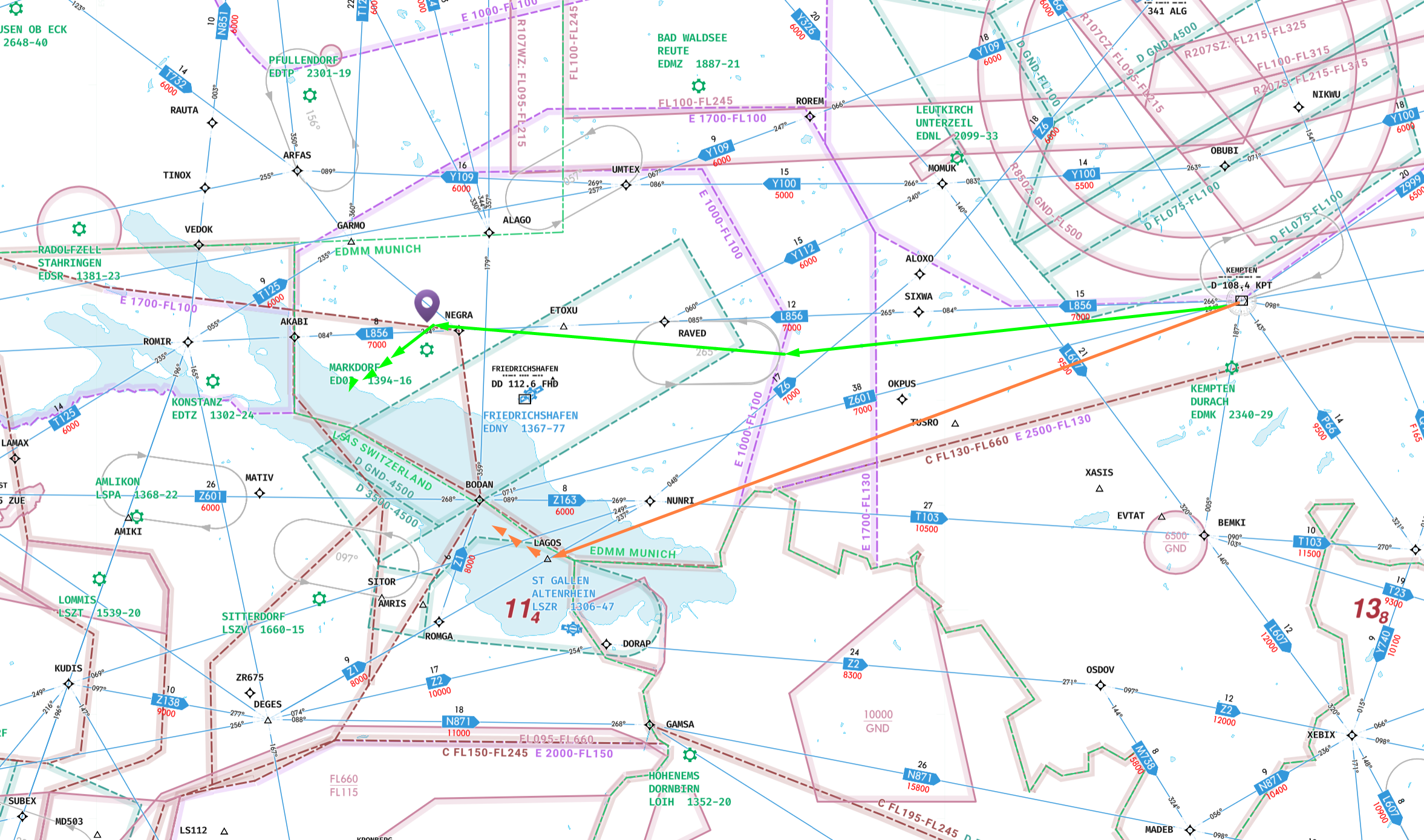
For arrivals from the north and east via KPT VOR, the published KPT1F arrival can be expected during RWY 06 operations. In most situations, the STAR is flown until MOKOP, after which aircraft typically receive radar vectors for a left turn into the northern downwind before transitioning onto final approach for RWY 06.
As an alternative to the full KPT1F arrival, aircraft may also receive direct routing from KPT towards LAGOS (RNAV waypoint). From LAGOS, crews should expect transition into the visual approach environment for RWY 06, often combined with shoreline vectoring south of the airport before turning onto final approach.
The southern arrival transition via LAGOS and subsequent visual approach environment should only be expected during clear visibility and VFR weather conditions. Reduced visibility, low cloud layers or adverse weather conditions will typically result in conventional vectoring patterns and instrument-based arrival sequencing instead.
Both procedures are commonly used to reduce unnecessary track miles and improve arrival sequencing efficiency during low and moderate traffic conditions.
RWY 06 – Arrivals via ARFAS, ZUE and ROLSA
Arrivals from the west and northwest via ARFAS, ZUE and ROLSA (via DEGES) can generally expect radar vectoring and direct transition into the RWY 06 approach environment rather than full procedural STAR operations.
Depending on traffic conditions and runway sequencing, ATC will typically provide direct descent instructions followed by vectoring into the approach environment. Arrivals via ARFAS can commonly expect transition into the northern downwind before sequencing onto final approach. Aircraft arriving via ZUE and ROLSA, however, will more frequently receive direct vectoring towards a straight-in ILS approach for RWY 06.
Due to the relatively compact airspace structure around EDNY, these arrivals are usually handled with minimal track miles and shortened transition phases.
RWY 24 – Arrivals
Arrivals via ARFAS during RWY 24 operations can generally expect the standard ILS approach for RWY 24. Due to the favorable arrival geometry from the west, vectoring requirements are usually minimal under normal traffic conditions.
Aircraft arriving from KPT can expect either radar vectoring or direct Routings towards the final approach course, often resulting in shortened transitions directly into the ILS approach environment.
Arrivals via ZUE are commonly routed into the northern downwind via UMTEX before being sequenced onto final approach for RWY 24. Depending on traffic volume and weather conditions, additional vectoring may be issued during the downwind phase.
Aircraft arriving via ROLSA can frequently expect direct routing towards HOFAZ in order to establish the southern downwind for RWY 24 operations. This routing is commonly used to efficiently separate western and northwestern arrival streams before transition onto final approach.
Approach
Approach operations at EDNY are characterized by a highly flexible and vector-based arrival environment rather than strict procedural sequencing. Due to the airport’s compact regional airspace structure, approaches are frequently shortened and adapted dynamically depending on traffic volume, weather conditions and runway configuration.
Both instrument and visual transitions are commonly used during daily operations. Crews should expect a combination of radar vectoring, direct routings and shortened approach profiles, particularly during low and moderate traffic situations. Full published procedures are available and may be flown when required, but operationally, ATC will often prioritize efficient sequencing and minimal track miles.
Approach environments at EDNY can vary significantly between RWY 06 and RWY 24 operations. While RWY 24 generally supports more conventional straight-in profiles, RWY 06 operations frequently involve visual transitions, shoreline vectoring and shortened final approach setups.
Due to the close interaction between IFR airline traffic, general aviation activity and regional airspace constraints, continuous situational awareness and early approach preparation remain essential during all arrival operations into EDNY.
RWY 06 – Approaches
RWY 06 operations at EDNY support multiple approach transition concepts depending on arrival direction, traffic conditions and weather situation. Due to the airport’s flexible and vector-based arrival environment, approaches are frequently adapted dynamically by ATC in order to reduce track miles and improve sequencing efficiency.
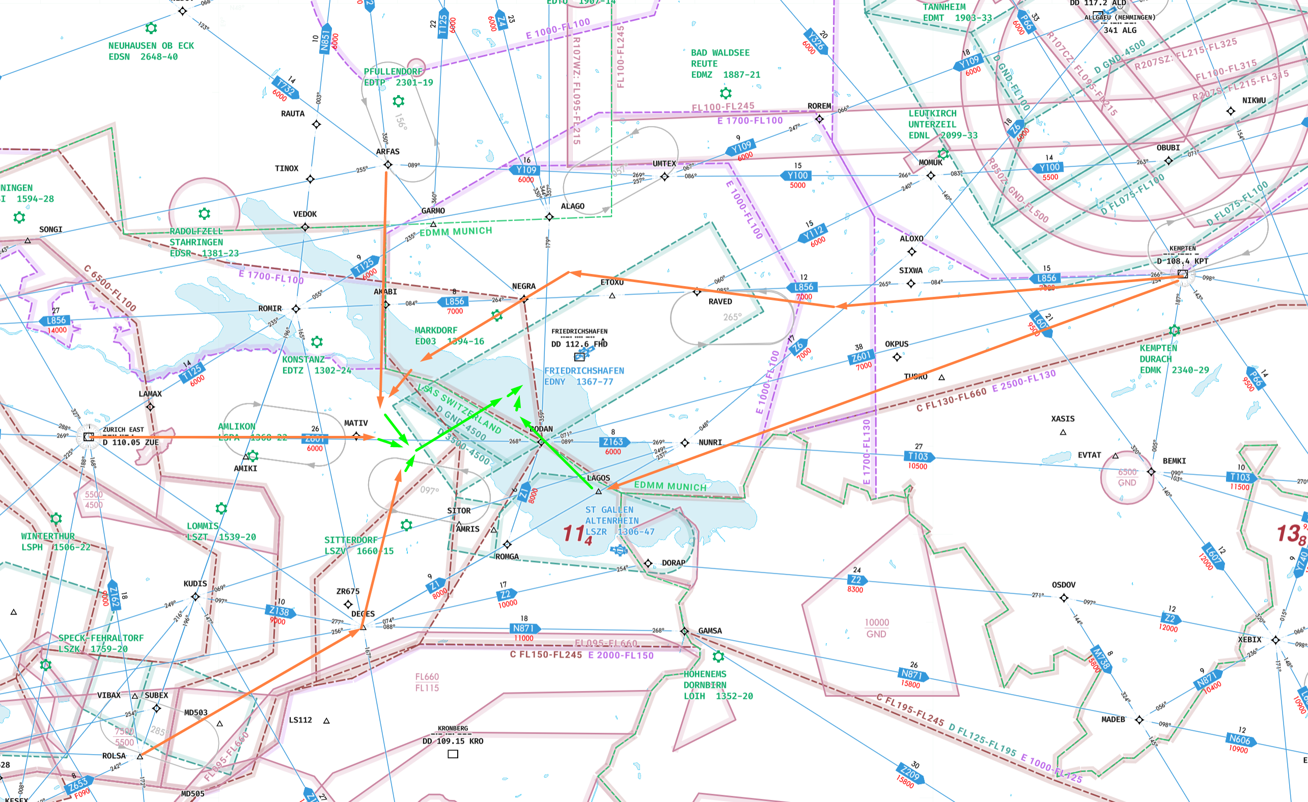
*orange is the conection between the entry point and tansition into the final approach sector. Green are the expected turns into the final approach.
Aircraft arriving via ARFAS will commonly receive transition towards the ILS environment via NY610 rather than entering a conventional downwind pattern. This transition typically results in a relatively direct setup onto the instrument approach environment for RWY 06 with minimal vectoring requirements under normal traffic conditions.
Depending on sequencing requirements and traffic density, additional radar vectors may still be issued prior to final intercept.
Arrivals via ROLSO (from DEGES) and ZUE commonly receive direct vectoring towards a straight-in approach setup for RWY 06. These arrivals typically involve minimal transition phases and are operationally preferred whenever traffic conditions permit efficient direct sequencing.
During favorable weather and clear visibility conditions, aircraft may receive direct routing towards LAGOS (RNAV waypoint) for the southern visual arrival environment into RWY 06.
From LAGOS, ATC will typically provide visual vectoring south of the airport along the Lake Constance shoreline before turning aircraft onto a shortened visual final approach. This transition is primarily used during VFR conditions and allows highly efficient arrival sequencing with minimal track miles.
Due to the close proximity of recreational VFR traffic along the lakeside area, increased situational awareness is required throughout the visual transition phase.
RWY 24 – Approaches
RWY 24 operations at EDNY generally support more conventional and stable approach profiles compared to RWY 06 operations. Due to the runway orientation and surrounding airspace structure, arrivals are frequently sequenced using extended downwind transitions or direct vectoring towards the ILS environment depending on arrival direction and traffic situation.
Aircraft arriving via ARFAS will commonly receive direct transition into the standard ILS approach environment for RWY 24. Due to the favorable arrival geometry from the west, only minimal vectoring is usually required before interception of the final approach course.
This arrival concept is operationally preferred whenever traffic conditions allow uninterrupted sequencing.
Traffic arriving from KPT can expect radar vectoring or direct routings towards the final approach environment for RWY 24. Depending on sequencing requirements, aircraft may either receive shortened vectoring directly onto the ILS or transition through modified arrival paths before final interception.
Due to the compact airspace environment around EDNY, these arrivals are frequently optimized to reduce unnecessary track miles.
Arrivals via ZUE are commonly routed towards UMTEX before entering the northern downwind for RWY 24 operations. From the downwind, aircraft are typically vectored onto base and subsequently established on final approach.
Aircraft arriving via ROLSO (from DEGES) can frequently expect direct routing towards HOFAZ in order to establish the southern downwind for RWY 24 operations.
Final
RWY 06 – Final Approach
The primary instrument approach for RWY 06 is the ILS RWY 06 procedure.
ILS Information
- ILS Identifier: IFHE
- Frequency: 111.9 MHz
- Course: 057°
- Glideslope: 3.10°
Final Approach Characteristics
The final approach segment for RWY 06 is comparatively short due to the compact airspace environment around EDNY and the operational preference for shortened vectoring patterns. Aircraft are typically established on final between 6 and 10 NM from touchdown, depending on traffic conditions and arrival routing.
Standard intercept altitude for the glideslope is approximately 4,000 ft during conventional ILS intercept setups. However, due to the flexible vectoring environment around EDNY, lower intercept altitudes and shortened final approaches are common during low traffic situations.
During visual conditions, ATC may combine the ILS environment with visual vectoring techniques, particularly for arrivals transitioning via LAGOS and the southern shoreline area.
Despite the compact approach environment, the RWY 06 ILS provides stable guidance and good situational awareness throughout the final approach phase.
CAT I Minima
- Decision Altitude (DA): 1,539 ft
- Decision Height (DH): 204 ft
- Required Visibility / RVR: 750 m
RNP Alternative
As an alternative to the ILS procedure, RNAV (RNP) approaches for RWY 06 are available and may be used during:
The RNP approach generally follows a similar arrival environment but may involve slightly different descent profiles and lateral guidance characteristics compared to the ILS procedure.
RWY 24 – Final Approach
The primary approach infrastructure for RWY 24 is the ILS RWY 24 procedure, which represents the standard arrival environment during most operational conditions at EDNY.
ILS Information
- ILS Identifier: IFHW
- Frequency: 111.9 MHz
- Course: 236°
- Glideslope: 3.00°
Final Approach Characteristics
RWY 24 generally supports longer and more stable final approach profiles compared to RWY 06 operations. Aircraft are commonly established on final between 8 and 12 NM from touchdown, depending on traffic density and arrival direction.
Standard glideslope interception normally occurs around 4,000 ft during conventional ILS setups. Due to the favorable runway geometry and open terrain environment west of the airport, RWY 24 operations usually provide stable and predictable approach conditions.
Arrivals transitioning via UMTEX or HOFAZ commonly receive vectoring onto base leg before interception of the final approach course, while arrivals from ARFAS may receive near straight-in setups with minimal vectoring requirements.
The RWY 24 ILS environment is generally considered the standard and operationally preferred final approach setup at EDNY. RWY 24 additionally supports operations up to CAT III depending on aircraft capability, operator approval and current airport infrastructure status, making it the preferred low visibility runway at the airport.
CAT I Minima
- Decision Altitude (DA): 1,631 ft
- Decision Height (DH): 264 ft
- Required Visibility / RVR: 600 m
RNP Alternative
The RNP approach is commonly used during:
- training operations
- navigation redundancy scenarios
- specific ATC sequencing requirements
Due to the relatively uncomplicated terrain environment west of the airport, the RNP procedure for RWY 24 generally allows stable descent management and predictable final approach guidance comparable to the conventional ILS environment.
Departure
RWY 06 – Departures
Departure operations from RWY 06 at EDNY are structured around a limited number of operationally preferred SIDs in order to ensure terrain separation, efficient climb profiles and simplified regional traffic management.
BlueLake Airways only utilizes the following standard departure routes from RWY 06:
BEMKI Departures
Flights departing towards the northeast, east, southeast and south are routed via the BEMKI departures.
Applicable SID designators:
- BEMKI 1E
These departures provide the preferred routing structure for traffic transitioning towards southern Germany, Austria and eastern European destinations.
Due to the rapidly rising Alpine terrain south and southeast of EDNY, direct departures towards the southeast are operationally avoided. All traffic towards these sectors is therefore routed initially via BEMKI in order to ensure safe terrain clearance and structured departure sequencing.
AMIKI Departures
Flights departing towards the southwest are routed via the AMIKI departures.
Applicable SID designator:
- AMIKI 1E
This routing is primarily used for traffic towards Switzerland, France and southwestern European destinations.
The departure profile generally allows efficient climb management while maintaining separation from nearby cross-border airspace structures.
ALAGO Departures
Flights departing towards the northwest and north are routed via the ALAGO departures.
Applicable SID designator:
- ALAGO 1E
This departure is commonly used for traffic towards western and northern Germany as well as destinations further into northern Europe.
Due to the comparatively open terrain environment north of EDNY, climb restrictions are generally less demanding than on southern departure sectors.
Non-Standard SIDs
All other published RWY 06 SIDs are generally not utilized by BlueLake Airways and are therefore not planned during standard dispatch operations unless specifically required by ATC or operational necessity.
RWY 24 – Departures
RWY 24 departure operations follow the same general routing philosophy as RWY 06 operations, with departures structured around a reduced set of preferred SIDs optimized for terrain avoidance and operational efficiency.
BEMKI Departures
Flights departing towards the northeast, east, southeast and south utilize the BEMKI departures.
Applicable SID designators:
- BEMKI 1W
These procedures provide the preferred departure structure for traffic routing towards Austria, southern Germany and southeastern European destinations.
Due to terrain considerations associated with the Alpine region south and southeast of EDNY, direct southeast departures are not conducted. Aircraft are instead routed initially via BEMKI before continuing towards their planned route structure.
AMIKI Departures
Flights departing towards the southwest are routed via the AMIKI departures.
Applicable SID designator:
- AMIKI 1W
This departure is commonly used for traffic towards Switzerland, France and southwestern Europe and generally supports efficient transition into upper airspace structures west of Lake Constance.
ALAGO Departures
Flights departing towards the northwest and north utilize the ALAGO departures.
Applicable SID designator:
- ALAGO 1W
This SID provides the standard routing structure for northern and northwestern traffic flows departing EDNY.
Compared to southern departure sectors, terrain influence during the initial climb phase is significantly reduced.
Non-Standard SIDs
All other published RWY 24 SIDs are generally not utilized by BlueLake Airways and are therefore excluded from standard dispatch planning unless specifically required for operational reasons or ATC instructions.
Airspaces
The airspace environment surrounding EDNY is relatively compact and operationally demanding despite the airport’s regional size. Due to the close proximity of multiple international airspace boundaries and the nearby Zurich terminal environment, crews should expect frequent ATC coordination, compressed arrival profiles and dynamically changing vectoring instructions.
One of the most significant factors affecting EDNY operations is the immediate proximity of the Zurich (LSZH) TMA. Large portions of the upper airspace south of EDNY are already controlled by Zurich Approach sectors, while major Zurich departure corridors are located directly south of Lake Constance. As a result, departures and arrivals around EDNY frequently operate in close proximity to descending and climbing Zurich traffic.
The available maneuvering space for EDNY arrivals is therefore comparatively limited. Aircraft descending from FL100 often have only a short distance available to reduce speed, configure and establish onto the final approach environment. Especially during RWY 06 operations, this can result in compressed descent profiles, rapid altitude changes and shortened vectoring patterns.
Due to the compact approach sector, crews should remain prepared for:
- high descent rates
- early speed management requirements
- rapid configuration changes
- late vectoring onto final
- direct-to clearances replacing conventional sequencing
Additionally, EDNY is located close to the FIR boundaries of:
- Langen Radar
- Munich Radar
- Zurich Radar
This creates a highly coordinated cross-border operational environment where aircraft may transition between multiple ATC sectors within very short timeframes. Depending on arrival and departure direction, frequent frequency changes shortly after departure or during descent should be expected.
The interaction between German, Swiss and Austrian traffic flows can also create temporary traffic bottlenecks around the Lake Constance region, particularly during online network events or peak evening operations. Efficient energy management and proactive descent planning are therefore essential for stable operations into EDNY.
ATC / Vatsim
Frequences
Airport Frequencies
- Friedrichshafen Tower: 120.080
- ATIS / Information: 129.605
EDNY does not operate dedicated Delivery or Ground frequencies. All startup, taxi and departure clearances are handled via Tower.
Approach/Departure Frequencies
Approach
- Alps Radar: 119.925
Departure
- Alps Radar: 119.925
Center Frequencies
Munich Radar
- Zugspitze sector: 134.150 (main frequency)
- Füssen sector: 133.550
*Expected for all KPT arrivals and BEMKI departures
Langen Radar
- South sector: 123.010 (main frequency)
- Baden sector: 131.300
*Expected for all ARFAS arrivals and ALAGO departures
Swiss Radar
- South sector: 133.050 (main frequency)
- Baden sector: 133.905
*Expected for all ROLSA/ZUE arrivals and AMIKI departures
Operational Notes
- Expect rapid frequency handoffs after departure.
- Multiple radar sector changes during arrival and departure are normal due to the close proximity of FIR boundaries.
Coverage
EDNY coverage on VATSIM can vary significantly depending on time of day, regional events and staffing availability. Due to the airport’s relatively small traffic volume, full local staffing is uncommon outside of major events.
The most frequently staffed position is Friedrichshafen Tower, which usually handles all ground and runway operations due to the absence of dedicated Delivery and Ground positions.
Approach services are commonly provided by:
During low traffic periods, arrivals and departures are often handled efficiently with highly flexible vectoring and shortened Routings. When no local ATC is online, pilots should expect standard UNICOM operations with self-coordination on the apron and within the traffic pattern.
During major VATSIM events in the southern Germany and Switzerland region, traffic density around EDNY can increase rapidly due to the airport’s proximity to the Zurich airspace environment and the Lake Constance area. In these situations, pilots should expect:
Because EDNY lies close to several FIR boundaries, ATC responsibility may also change dynamically during online operations, resulting in more frequent handoffs than at many comparable regional airports.